Digital Reconstruction 3D walkthrough of Virupaksha Bazaar Street of Hampi
Mamata N. Rao, Pallavi Thakur
|
Many of us would have heard about the Vijayanagara kings specially Krishandevaraya
and about the place Hampi being introduced in our school history. The descriptions
of precious stones, diamonds, and many other riches sold on the bazaar streets of
Hampi rings a bell in our minds and makes us visualize about the streets arouses
inquisitiveness to know more about the Hampi bazaar streets. Our team at National
Institute of Design (NID) R and D Campus had the opportunity to take up a research
project funded by Department of Science and Technology (DST), Government of India,
that focuses on Hampi bazaar streets with the objective to look at architectural
reconstructions and visualizations of life events/activities in Hampi bazaars of
Vijayanagara period. Hampi is a world heritage site that came into existence during
the Vijayanagara period (1327-1674 AD) and presently it is in ruins.It is located
over an area of 26 sq km and is renowned for its magnificent temples, city layout,
the bazaar streets and its
|
 |
activities. Today most of the structures stand in ruins.
The ruins show the buildings for the royals and the temple complexes, without any
trace of domestic dwellings for the ordinary. The bazaars are the only place where
there are some archeological, descriptive literary evidences describing the activities
of all classes of people and the festive occasions associated with temples. The
bazaars of Vijayanagara were also very famous and have been stated by a number of
visitors and merchants who visited Vijaynagara during the rule of the various kings.
The major Bazaar Streets of Hampi are situated in front of the major temple complexes
and are 1. Virupaksha temple Bazaar Street 2. Vittala temple Bazaar Street 3. Krishna
temple Bazaar Street 4. Achyutaraya temple Bazaar Street 5. PanSupari Bazaar Street
(Royal Bazaar Street). In this article we will discuss about the digital architectural
reconstruction of Virupaksha Bazaar Street.
When we began our field visits for data collection we heard a short narration on
the birth of the word “market” from a tourist guide. The narration speculated
that this word has its birth from the Kannada word “marukatte” (meaning
a platform for selling commodities) which later on evolved as “market”
in English language. It is said that this came from the “marukatte”
of Hampi or the Hampi bazaars as we refer today. Hampi bazaar streets can be considered
as one of the first attempts seen in Indian building history to provide organized
retail space at a city level, as most of them would have been unorganized market
activities.
Virupaksha Temple Bazaar Street
The street in front of Virupaksha temple complex at Hampi is referred to as VirupakshaBazaar
Street. The street is 800m long and 13.8m wide with the temple complex at one end
and the Nandi Mantapa at the other end just below Matanga Hill. According to Lakkanadandesha’s
literary workSivatattvacimtamani,Devaraya II (1424- 46) built this street
in the 15th century AD. The king had ordered the stones to be crushed
to level the street and vegetation to be removed for building activities. This
street has been described by Domingo Paes, a 16th century Portuguese
horse trader, who visited Vijayanagara during the reign of Krishnadeva Raya (1471-1529)as
“a street with beautiful houses with balconies and arcades, in which are sheltered
the pilgrims and there are also houses for the upper classes; the king has a palace
in the same street, in which he resides when he visits the pagoda (referring to
Virupaksha temple gateway or gopuram).This bazaar street is also well known as the
famous car street for festive occasions, especially for the annual Rathotsava Festival,
celebrating the marriage of Lord Virupaksha and Pampa Devi which continues till
date. Historians say that merchants, pilgrims and other visitors were accommodated
during festival time by erecting temporary bamboo structures and awnings. Further
according to literary sources the street had ‘Mathas” or institutes
run by religious bodies funded by the kings or “Rayas” (as the Vijayanagara
kings were so called), wealthy people and merchants. They promoted education, charity
and other religious activities. VirupakshaBazaar Street was one of the busiest and
most important streets where trade and religion intermingled together to make it
a very dynamic bustling place. It was visited by most of the foreign travelers
and merchants of that period. Later A.H Longhurst, an officer of Madras Presidency
who authored a book on Hampi, writes about the Virupaksha bazaar street as the second
longest and the best preserved street compared to other bazaar streets.
Site context
The Virupaksha Street has more than 50 structures placed close to one another some
with gaps as less as 0.5 m. These structures were occupied people until evacuated
two years ago and had undergone constructional alterations. Such a site context
rendered laser and other modern large-scale digital data capture methods unsuitable.
Building Digital Models
a) Creating an urban level map of Hampi:
In the study related to bazaar streets of Hampi it was essential to understand the
city layout and the linkages at city level. We took up the study of various literary
sources with the focus to chart old roads, networks, linkages, the extent of temple
Bazaar Streets, the entry gates and connections to other complexes and areas. We
simultaneously looked at secondary sources of published maps and traced to create
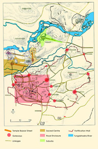
a digital comprehensive map of Hampi shown in Fig 1
with the following elements:
• The five
Bazaar Streets and environs
• Royal
enclosure
• Linkages
between bazaar streets royal enclosure and other places
• Gateways
along various fortress walls
|
b) Creating Footprint Plan for
Virupaksha Street:
We have made use of the plans for various structures published in Vijayanagara Architectural
Inventory of the Sacred Centre by Mitchell and Wagoner. The plans for structures
were scaled/aligned with rooftops of buildings on Google maps to create a digital
footprint for the bazaar street, shown in Fig. The footprint has been continuously
improved to include structures that can be seen today based on current excavations
being taken up by ASI. This plan was suitable for visualizing a rough massing model
of Virupaksha Bazaar Street for further documentation, analysis and interpretation.
|

|
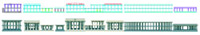
c)
Broad Architectural typologies of Structures for massing
models: We categorized the various 50+ structures on the street
into 5 main architectural typologies i.e Mantapas, Colonnades, Pavilions, Gateways
and Shrines. Using the overall form for each typology we created street massing
model.
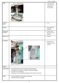
d) Field Documentation: An extensive
photo documentation focused on the architectural typologies and mapping their feature
/ components in the form of a detailed two dimensional feature matrixfor Broad and
Sub-category under each architectural typology attributes as below:
- Plans and elevations
- 3D models
- Column spacing, Column types seen inside each ?structure
- Plinth
- Column shaft and capital details
- Parapet and eave details
- Staircase and openings
- Iconography
This matrix serves as a library of instances for parapet, plinth, columns etc that
we have used as samples for reconstruction where it is found to be missing for the
structure. The study of iconography for each of the architectural typology would
help us understand the functional context of these structures such as use as Mathas
some with Shaivaite icons and others with Vaishnavite icons. Mathas acted as chatras,
educational centres; while the colonnades mostly for selling.
|
e) Sub Architectural typology: Each typology
was furtherdivided into sub categories based on the number of floors, column types,
presence of porch. For example the Mantapa typology was further divided into sub-category
based on i) the number of floors (single or double) ii) presence or absence of front
porch with double height columns ii) The number of frontal columns seen in the front
porch (varied from 4 to 8). The figure below shows the classification.
f) Reconstructions of the structures:
We arrived at rules by looking at samples for architectural features / components
available in the structures of that typology.The rules for reconstruction would
be as follows:
Identify the type of architectural typology and the sub-typology
|
 |
Examine and locate if there are any samples of missing features available as remnants
in the same structure. If yes then reconstruct based on the remnant feature available.
If not then we would look at samples of missing features available under the same
sub category or else move up in the immediate parent category and moving till the
broad (main) parent category.
The feature-basedmatrix also contains instances of architectural features that can
be compared and contrasted missing elements considered for reconstruction.
|
We have finished the 3D models for all well-preserved structures with feature based
reconstructions for plinth, eaves and parapet.
|
 |
Acknowledgement?
We thank the Department of Science and Technology,Government of India for funding
the project “Representation of Art, Artifacts and Architecture of Hampi Bazaars
from a Design Perspective” DST No: NRDMS/11/1586/09/Phase- II/Project No 15.The
authors thank institutional support provided by National Institute of Design (NID).The
role of DeepanjanSarkar3D artist,Meenakshi Singh a Fine Artist and Mahesh Kanzarkara
web developer is acknowledged.
We would also thank the various historians, anthropologist and Subject matter Experts
who have made this project an enriching and dynamic phenomenon.
Authors
Mamata N. Rao, Senior Faculty and Principal Investigator
for Digital Hampi Project at National Institute of Design, Research and Development
Campus Bengaluru.
&
Pallavi Thakur Project Coordinator, Digital Hampi
Project, National Institute of Design, Research and Development Campus Bengaluru