Sardar Sarovar Narmada Project, Gujarat
An Engineering Marvel-Unprecedented
Rivers in India, since time immemorial, have nurtured human existence and have occupied sacred status in the hearts of millions of Indians. The perennial river Narmada, considered to be one of the seven sacred rivers of India, makes her way through Gujarat before culminating into the Gulf of Cambay. With her dignified presence and the Life sustaining capabilities, Narmada continues to be the ‘Life Line of Gujarat’. Sardar Sarovar Narmada Project initiated by the Government of India to resolve the water crisis in the state of Gujarat is indeed an unprecedented engineering marvel.
 |
Built Expressions in an exclusive and comprehensive interaction with K. Srinivas, Retired Chief Engineer, Sardar Sarovar Narmada Nigam Project Ltd, brings to you the salient features of this mega project circumscribing the challenges while implementing the project as envisioned. |
Introduction
 |
 |
The bifurcation of the erstwhile Bombay State into Maharashtra and Gujarat took place on May 1, 1960. Both the states took different paths and followed distinct development strategies and policies to achieve rapid economic and social development. At the time of the bifurcation, Maharashtra’s per capita income was about 10 per cent higher than Gujarat’s. The share of primary sector activities in the total income was 46 per cent in Gujarat and 42 per cent in Maharashtra, making both the states largely agriculture-based economies. However, geographically a large part of Gujarat was drought prone and extremely water scarce. Surface irrigation opportunities and potentials were limited, making agriculture in the state rain-dependent and vastly vulnerable. Drinking water in thousands of villages and hundreds of urban centres was a serious problem. It led to consequent problems of health and hygiene resulting in higher mortality, particularly among infants and children. For its overall growth and development, Gujarat had to focus on the agriculture and animal husbandry sectors by tapping all possible sources and potential of irrigation in the state. The successfully launched co-operative movement among milk producers effectively addressed the problems of employment and poverty and ensured regular flow of income in the rural areas of the state. Problems of drinking water and irrigation, however, still remained.
The Geography
The geographical area of the State is approximately 1, 96,000 sq.km, which is around 6% of the total area of India. As per 2011 census, the population of the State is 600 Lakhs, which is 5% of the population of the nation. The Gujarat state has 185 rivers out of which only 8 are perennial and Narmada is one among them. All these 8 rivers are geographically disposed in the Southern Gujarat. The South Gujarat is 30% of Gujarat’s total land and it has 70% of States water which is 38100 million cubic meters of surface water, where as the rest 70% of the Gujarat has only 30% water. The above available surface water is only 2% of the entire quota of the country. Therefore it can be seen that the distribution of surface water is highly skewed.
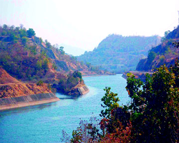
The river Narmada is the largest perennial river in Gujarat. The State regarded the project as inevitable and essential for its economic and social development. It was politically expedient to call it the “Life line of Gujarat”, even though Gujarat would be one of the four States benefitting from the project.
Brief History
The Government of India (GoI) constituted the Central Waterways, Irrigation and Navigation Commission (CWINC) under the chairmanship of A.N. Khosla in April 1945 to act inter alia as a central fact finding, planning and coordinating organisation with the authority to facilitate construction work. The then Governments of Central Provinces & Berar and of Bombay requested CWINC in 1946 to take up investigations on the Narmada river system for basin-wide development of the river including flood control, irrigation, power and extension of navigation. CWINC took up studies of the topography and hydrology of the basin in the beginning of the year 1947. These studies revealed excellent storage sites on the main river and some of its tributaries. Many sites were inspected by engineers and geologists who, among other things, recommended detailed investigations for a Broach weir below gorge on the Narmada.
 |
The GoI Ministry of Works, Mines and Power appointed in 1948 an ad hoc Committee headed by A.N. Khosla, Chairman, CWINC to scrutinise the estimates based on investigations, inter alia for the Broach Weir as advised and to recommend priorities. The ad hoc Committee observed that the Narmada Basin appeared to hold great 13 development and would have a far-reaching effect on the economic advancement of the country in general and the basin in particular. The committee recommended detailed investigations of four projects ( namely, Bharuch (Gujarat), Bargi, Tawa and Punasa in Madhya Pradesh) including the Broach Project. Gol approved the estimates of investigation in March 1949 and CWINC took up their investigations in the same year. Investigations of all the projects except Bargi were completed and the project reports prepared. CWINC was re designated in 1951 as the Central Water and Power Commission (CWPC).
Central Water and Power Commission (CWPC)
CWPC carried out preliminary geological and topographical surveys of all the candidate sites first proposed a site near Gora village for a weir with Full Reservoir Level (FRL) 160 ft. in the first stage, envisaging an annual irrigation of about 400,000 hectares (1,000,000 acres) through a right bank canal. The project report was first prepared in the beginning of the year 1956. The Member (Designs & Research), CWPC inspected the project site in February 1957 and suggested further investigations for the Gora site and also at Navagam, about 3 km upstream, where there was exposed rock in the riverbed affording high abutments that would allow raising the dam height. The Navagam site was finally chosen in consultation with the then Government of Bombay.
In 1959 CWPC modified the Gora weir project considering the Navagam site. Its implementation was envisaged in two stages - FRL 160 ft. in Stage I, with provision for a wider foundation to enable raising it to FRL 300 ft in Stage Two.
The Bharuch Irrigation Project (BIP) Report prepared by CWPC was scrutinised and reviewed by the Bombay Government. The main modifications it suggested related to the raising of the FRL of the dam to 320 ft. in stage II, provision of a power house in the river bed and a power house at the head of the low level canal.
However, less than a year later, on 1st May, 1960, Bombay was bifurcated into two states - Gujarat and Maharashtra. BIP stage I was cleared by the Planning Commission in August 1960, and its acceptance was communicated to the Government of Gujarat (GoG). The acceptance of stage-I also provided for wider foundations and additional length for a masonry dam and building an earth dam to full cross-section corresponding to the dam with FRL 320 ft.
 |
The dam at FRL 162 ft. in stage-I provided for diverting water into a low level canal at Full Supply Level (FSL) 160 ft. to command 538 000 hectares in the Broach and Baroda districts and annual irrigation for 389,000 hectares. Stage-II envisaged the raising of the weir and providing crest gates for FRL 320 ft. Irrigation was proposed to be extended to an additional area of at least 364,000 hectares by means of a high level canal off-taking with FSL 295 ft. Power generation to the extent of 625 MW at 60 per cent load factor (LF) was also envisaged in the project. GoG gave administrative approval to Stage I in February 1961.
The surveys of the command area and reservoir submergence area were done by the Survey of India. GoI indicated that a much larger area could be commanded by a +300 canal and that it was possible to store more water if the dam height could be raised beyond +320. Accordingly, after detailed engineering and geological investigations in 1963, the dam site was shifted 5.6 km upstream to Navagam dam site No. 3, which was suitable for construction of a high dam.
Navagam is the last in the series of dams of the Narmada Valley Project. Hence, its design must necessarily consider probable future planning and phasing of projects for the control and use of the waters upstream. With upstream consumptive use estimated by MP and the increased water requirement of Gujarat for areas to be commanded by the proposed Narmada high level canal, it was necessary to apportion the waters and, on the basis of such apportionment, to decide the optimum height of the Navagam Dam. Until this was done, it was not possible to proceed with its construction.
 |
It appears that until the year 1960 engineers and planners believed that the gorge in the 113-km stretch between Harinphal and Navagam could not afford sizeable storage, even if the Navagam dam’s height Was to be raised. However, the available topographic survey sheets and other survey data by Gujarat Engineers indicated that the gorge between Navagam and Harinphal could store a very large amount of water if the Navagam dam was to be raised to the same height as Harinphal to provide a terminal storage reservoir. The proposition appeared so promising that GoG entrusted to the Survey of India the work of carrying out a contour survey by aerial photography for assessing the storage capacity of the proposed high Navagam dam. The advantages of the high dam are very large storage capacity, greater harnessing of Narmada waters, increased irrigation from the high level canal and an effective flood cushion to downstream areas.
A meeting of the Chief Ministers of Gujarat and MP was arranged at Bhopal with good offices of the Union Minister for Irrigation and Power, GoI in November 1963. It was agreed at the meeting that the Narmada should be developed in the best national interest and that FRL of Navagam dam should be 425 ft. The MP Government, however, did not ratify the Bhopal Agreement and did not actuate its terms.
In September 1964, GoI with the concurrence of the concerned states appointed the Narmada Water Resources Development Committee (NWRDC) under the chairmanship of Dr. A. N. Khosla, then Governor of Orissa.
The Khosla Committee
The Khosla Committee held a number of sittings and also met a number of times with the representatives of all concerned state governments. The committee invited their viewpoints and proposals on the schemes for harnessing the Narmada Waters. Each submission from a state was referred by the committee to the other States, eliciting their comments on it. Comments and responses on almost all the documents initially submitted by the concerned states were received. The committee also made various independent studies and made on- the-spot inspection of the Navagam dam site and its commanded areas as well as the Punasa (Indira Sagar) site in MP.
In September 1965 the committee forwarded a unanimous report to Gol giving an outline of the Master Plan for the development of the Narmada valley. The Master Plan envisaged twelve major projects to be taken up in MP and one in Gujarat.
For Gujarat the committee recommended that the terminal dam should be located at Navagam, the optimum FRL of Navagam dam be 500 ft, the FSL of Navagam canal be 300 ft at its off-take and the installed capacity of the river bed power station and canal power station be 1000 MW and 240 MW respectively. Irrigation benefits from the Navagam dam would be shared by Gujarat and Rajasthan and power generation would be shared by MP, Maharashtra and Gujarat.
While GoG broadly endorsed the recommendations of the Khosla Committee, the Governments of Maharashtra and MP did not accept them. MP claimed absolute rights over the hydro-power which could be generated in its territory. It was not amenable to the submergence of any part of its territory by a dam in Gujarat and questioned the necessity of a high dam or a high level canal from this site. It also asserted that the Khosla Committee’s assessment of water availability at different sites was on the high side and that each State has constitutional right to develop hydro-electric power which it could generate in its own territory. Thus it rejected almost all the recommendations of the Khosla Committee.
 |
Maharashtra agreed generally with the basic considerations for drawing up the Master Plan by the Khosla Committee. It advocated restriction of the FRL of the Navagam dam to 210 ft. and a canal with FSL 185/190 to be taken from there for irrigation in Gujarat. It rejected almost all the recommendations of the Committee.
 |
On 22nd August, 1966 a meeting of the Chief Ministers of the four States was convened by the Union Minister for Irrigation and Power in New Delhi. It was also attended by the Union Minister of State for Irrigation and Power. At this meeting it was decided that the Chief Ministers of Gujarat and MP should meet as early as possible with a view to resolve the dispute amicably. Accordingly, in 1967, the two Chief Ministers held discussions at Pachmarhi on 23rd May and in New Delhi on 22nd June. Thereafter, the Union Minister of Irrigation and Power and the Chief Ministers of all the four states met in New Delhi on 18th December. None of these meetings could resolve the differences among the States.
Narmada Water Dispute Tribunal
In spite of GoI’s earnest efforts over six years to settle the dispute by negotiations, no mutually acceptable agreement was reached on the distribution, control and use of Narmada waters and the height of the Navagam dam. The differences only widened. GoG therefore petitioned GoI in 1968 to appoint a Tribunal under the Interstate Water Disputes Act, 1956. GoI issued a notification constituting the Tribunal on 6th October, 1969 and on the same date referred to it GoG’s petition dated 6th July, 1968. By their communication dated 16th October, 1969, GoI also referred certain issues raised by the state of Rajasthan to the Tribunal. In 1970 GoG decided to name the Navagam Reservoir as Sardar Sarovar and the Navagam Dam as Sardar Sarovar.
The tribunal identified two preliminary issues - namely, whether Rajasthan could be a party to the dispute and whether Gujarat could construct in its territory a dam that would submerge the territories of Maharashtra and MP - which were required to be resolved before adjudication. The tribunal, taking into account the fact that Rajasthan could not, by virtue of its location, control the waters of Narmada, decided that Rajasthan could not be a party to the dispute. It also held that the construction of a dam in Gujarat territory, involving consequent submergence of portions of territories of Maharashtra and MP could be a subject of water dispute, and that the tribunal had jurisdiction to give appropriate directions to MP and Maharashtra to acquire land for making available to Gujarat.
 |
After the tribunal had given its decision on the aforesaid preliminary legal issues, MP, Maharashtra and Gujarat agreed to the allocation of 500,000 acre feet of Narmada Water to Rajasthan for irrigation in Barmer and Jalore districts and 250,000 acre feet to Maharashtra. The tribunal accepted this agreement and gave its decision that Rajasthan and Maharashtra respectively were entitled to the specified share of Narmada waters. The tribunal also allowed Rajasthan to represent its case before it by virtue of agreement of the three basin states.
After considering all the material available to it, NWDT gave a final decision in December 1979. The main parameters of decision of the tribunal were as follows:
(a) Allocation of Narmada Water at 75 per cent dependable yield.
| |
Million
acre feet |
| Madhya Pradesh |
18.25 |
| Gujarat |
9.00 |
| Maharashtra |
0.25 |
| Rajasthan |
0.50 |
| |
------- |
| |
28.00 |
(b) Height of Sardar Sarovar dam
(i) Full Reservoir Level 455 feet (138.68 m)
(ii) Maximum Water Level 460 feet (140.21 m)
(c) Full Supply Level of Narmada Main Canal 300 feet (91.44 m)
(d) Allocation of Hydro-power generated at Sardar Sarovar Dam
| (i) Madhya Pradesh |
57% |
| (ii) Maharashtra |
27% |
| (iii) Gujarat |
16% |
The tribunal ordered setting up machinery to ensure implementation of its decision. Accordingly GoI constituted the Narmada Control Authority (NCA), Review Committee and Sardar Sarovar Construction Advisory Committee (SSCAC) to perform various functions to implement the decision of the tribunal.
B Planning Of Project
The Government of Gujarat (GoG) was cognisant of the fact that the successful completion of SSP would require comprehensive and systematic efforts in several directions. It recognised that the project planners would have to ensure equitable and timely supply of the limited quantity of water allocated by the tribunal. The project was also expected to avoid problems of waterlogging and salinity.
The project authorities were expected to make satisfactory arrangements regarding resettlement and rehabilitation (R&R). The project was to be planned so as to ensure sustainable development by paying attention to issues of environmental concerns. Environmental planning was to be done as an integral part of total project planning.
GoG wanted SSP to be planned, designed, constructed and operated with the highest standards of organisation and management and with a vision of the requirements of agriculture in the 21 st century. It was with this objective that GoG constituted the Narmada Planning Group (NPG) with a multi-disciplinary team of professional experts in engineering, agriculture, economics, sociology, ecology and environment and planning and public policy.
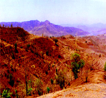
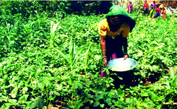
NPG commissioned about 25 technical studies covering aspects such as reservoir simulation, ground water investigation, supplies from en-route Rivers crossed by NMC, canal losses and special problems of NMC. NPG has noted that three-fourths of the command area is drought prone. With irrigation from the project this area would turn green. The economy of the state would become more stable and achieve a higher rate of growth.
3. Planning Of Dam
A. Evolution and Implementation of Sardar Sarovar Dam
Government of Gujarat (GoG) got Narmada Planning Group (NPG) to prepare the Sardar Sarovar Development Plan (1983) and presented it to the World Bank (WB) for its appraisal. For the Dam the Government set up a Dam Designs Review Panel (DDRP) in consultation with Government of India (GoI) and WB. DDRP carried out a total technical scrutiny with particular emphasis on safety of the dam against earthquakes and floods. The Design Organisation of Gujarat carried out all studies and presented them to DDRP, which endorsed the design. Similarly, other WB groups examined the design of the canal system.
 |
As mentioned above, the project was estimated to cost Rs.640.6 billion at 1986-87 prices. The World Bank agreed to provide credit assistance totalling US $450 million in 1985 for certain components of works included in Stage I (between River Narmada and River Mahi) of the project. Out of this US $300 million was for the dam and civil works of power houses, while US $ 150 million was for the main canal up to the Mahi River and part of the distribution system under this segment of the canal. The Bank in 1990 offered credit assistance of US $200 million for R&R and environmental protection measures for the entire project.
The Overseas Economic Co-operation Fund (OECF) of Japan agreed to provide credit of 28.5 billion Yen, equivalent to Rs.1.5 billion at the prevailing the exchange rate in 1986, for electrical components of the river bed power house.
SSP could not avail of the credit assistance to the extent of US $180 million from the World Bank and almost the entire credit assistance from the OECF as explained below.
Two significant developments took place after the NWDT gave its decision in December 1979. The Forest Conservation Act was passed in 1980 and the Environmental Protection Act in 1986. The passage of the FC Act, 1980, precluded any possibility of diversion of forest land to non-forest use as such use was expressly barred except through special dispensation of GoI. The submissions made before the tribunal had assumed that degraded forest lands would be made available for rehabilitation. Environment impact studies gradually came to be required on the basis of evolving guidelines, and environmental clearances became mandatory in the procedural progression of projects to investment clearance.
 |
In April 1986, the Ministry of Environment and Forests (MoEF) came up with a paper on the Environmental Aspects of the Narmada Sagar (NSP) and Sardar Sarovar (SSP) Multi-Purpose Projects. The study argued that it would take another two or three years to complete environmental impact studies for these two projects. The Ministry of Water Resources (MoWR), GOG and the Government of Madhya Pradesh (GoMP) pressed for environmental clearance for both projects to avoid delays and to ensure pari passu actions for environmental protection with construction. MoEF granted conditional environmental clearance in June 1987 for both NSP and SSP and forest clearance for SSP in September 1987.
The Planning Commission, after examining SSP, gave its clearance in October 1988 for an investment cost of Rs.640.6 billion, mentioned the need for compliance with conditionalities accompanying the environmental and forest clearance. GoG was required to give them priority. The programme of drainage and groundwater balance studies was to be completed for command areas beyond the Mahi (Stage 2 of the Project) and submitted for monitoring by the Planning Commission. Suitable water rates were to be devised to ensure annual revenues from the project sufficient to cover annual operating costs. Canal siltation studies were to be undertaken. Micro-level canal network plans and estimates were to be got ready within five years and the entire system planned to be completed in segments up to farm outlets so as to ensure early utilisation of available irrigation supplies. In according investment sanction, the Planning Commission also, therefore, laid down a number of environmental conditionalities.
 |
NWDT laid out a rehabilitation package which, certainly as far as landholders were concerned, was a considerable advancement over previous practice. The package did not cover other land related categories such as agriculture labourers, encroachers and coparceners. The tribunal did not recognise encroachers on forest land or non-forest lands as entitled to land benefits. Landless labourers would lose their livelihoods once the lands on which they were employed were submerged. They too must, therefore, be provided land in recompense. There were some merits in these arguments and Gujarat had by 1988 accepted both propositions. Both encroachers and the landless would, therefore, receive 2 hectares of land, with encroachers being entitled to ex-gratia compensation for encroached lands in excess of this figure. Gujarat also granted major sons full entitlement to land benefits. The R&R packages of Maharashtra and MP steadily improved and implementation has almost been completed.
The World Bank President, Barber Conable decided to appoint an Independent Review Mission (IRM) to review SSP. It started its work in September 1991. The IRM equated Narmada Valley Resettlement and Rehabilitation with human rights and cited the ILO convention 107 adopted in 1957 and ratified by India. The displacement in relation to the Narmada Valley Projects is not forced eviction in the sense of arbitrary ouster, but is in consonance with law, planned development and assisted relocation on generous terms, judicially determined, closely supervised and based on choice. Land acquisition is well established and is done in accordance with prescribed procedures.
 |
The IRM claimed that environmental and social trade-offs had been made and continued to be made without a full understanding of the consequences. It observed that as a result of these trade-offs benefits tended to be overstated, while social and environmental costs were frequently understated. The IRM also claimed that the Sardar Sarovar Project would not work as intended because there was not enough water in the river to deliver the designed benefits. It expressed apprehensions about considerable inundation and displacement that might be caused by the back-water effect of delta formation at the upper end of the reservoir. Finally, it stated its opinion that the wisest course would be for the World Bank to step back from the projects and to consider them afresh.
The IRM did offer some useful insights and could have made recommendations to improve the projects and their implementation. That would have been a real contribution. Instead, from small premises it asserted that rehabilitation was impossible and the project environmentally unworkable. The World Bank was also surprised that its constructive efforts and genuine concerns with ensuring a positive outcome through a sensible incremental pari passu approach was turned against it and it was put in the dock.
Finally, GoI informed WB that it was withdrawing SSP from the Bank’s lending portfolio, giving up an unspent $ 180 million. It instead decided to complete the projects without external assistance and agreed to provide them additional financial assistance in lieu of forgone amount of $ 180 million.
Thereafter, Narmada Bachao Andoian (NBA) filed a comprehensive writ petition seeking complete stoppage of all construction activities of SSP. It alleged that the project was not in national or public interest. It raised issues regarding R&R, environment and review of the Tribunal’s award. It submitted that it was necessary for some independent judicial authority to review the entire project, examine the current best estimates of all costs, namely social, environmental and financial, benefits and alternatives in order to determine whether the project was required in its then existing form in the national interest or whether it needed to be restructured or modified. It also submitted that no work should be resumed until environmental impact assessment has been fully done and its implications for the project viability assessed in a transparent and participatory manner. This could best be done, it was submitted, as a part of a comprehensive review of the project.
 |
After hearing NBA, the respondent states, namely MP, Maharashtra, Gujarat and Rajasthan, and the Union of India, and while issuing directions and disposing of the case, the Supreme Court observed that two conditions had to be kept in mind: (i) the completion of the project at the earliest and (ii) ensuring compliance with conditions on which clearance of the project was given, including completion of R&R work and taking ameliorative and compensatory measures for environmental protection in compliance with the scheme framed by the Government, thereby protecting Fundamental Rights under Article 21 of the Constitution.
The Supreme Court issued various directions to the states. A significant direction was that construction of the dam would continue as per the award of the tribunal. It also directed the states of MP, Maharashtra and Gujarat to implement the award and give relief and rehabilitation to the oustees in terms of the packages offered by them, and directed them to comply with any direction given in this regard by Narmada Control Authority (NCA) the Review Committee or the Grievance Redressal Authorities.
It also directed that if for any reason serious differences in implementation of the award arose and the same could not be resolved in the Review Committee, the committee could refer them to the Prime Minister whose decision in respect thereof would be final and binding on all concerned.
The Supreme Court further directed that every endeavour be made to see that the project was completed as expeditiously as possible.
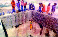
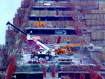
B Construction of Dam
The history of the project is long and chequered. Preliminary works like access roads and a colony at project sites were taken up in 1961. Additional colony, dam foundation, excavation and its treatment, rock fill dams, link channels, cofferdams, diversion of river flow, submersible bridges and experimental cross-drift for power house cavern could be taken up on large scale only in 1979 after the tribunal’s decision.
The commencement of major works of the main dam and power houses could be taken up in the year 1987-88 when MoEF gave the project environmental and forest clearance in 1987 and the Planning Commission gave investment clearance in 1988.
The work for construction of the dam was awarded in April 1987 with a stipulated period of construction period of 110 months. Accordingly, the work was to be completed by June 1996. The period of construction was extended by 19 months to January 1998.
 |
In the initial years of the contract work proceeded largely according to the programme. The progress started falling behind schedule from 1993-94, when 829,000 m3 of concrete against the planned quantity of 1,136,000 m3 could be placed in the dam. The work started lagging due to non-completion of R&R of affected families on time and after the Supreme Court order dated 5th May, 1995. However, by January 1998, nearly 80 per cent of the work of main dam was completed. Some significant work could be done in 1998-99 when the Supreme Court allowed raising of the dam from EL 80.3 m to 85 m. Finally the Supreme Court dismissed the writ petition and ordered on 18th October, 2000 that the work of the dam be completed expeditiously pari passu with R&R works and environmental protection measures.
 |
After the judgment of the Supreme Court, the Narmada Control Authority allowed construction of the dam from EL 85.0 m to EL 90.0 m during 2000-01. Thereafter, NCA in its 61st Meeting held on 17th November, 2000, decided important milestone dates for completion of the concrete dam. According to this programme the dam was programmed to be raised to 100 m, 110 m, 121 m and 138.68 m by June 2002, June 2003, June 2004 and June 2005 respectively. However, the actual progress could not meet the completion date of June 2005. The dam could be raised to spillway crest level of 121.92 m by December 2006. There is virtually no progress for last four years due to slow progress on R&R works and pending environmental clearances. Now MoEF has given environmental clearance in May 2010, but approval of the R&R Subgroup and that of NCA is awaited for raising the piers and installing gates. Once these approvals are given, it is planned to complete the work (especially the installation of 30 gates and bridge on the top of the dam) within a time span of three years.
C Hydrology
Systematic gauge and discharge observations on the Narmada were started only in the year 1947. This is when the then Central Waterways, Irrigation and Navigation Commission (CWINC) took up investigations to formulate flood control measures and to assess water resources available for irrigation, hydro-power etc. Prior to that, only a few high flood levels appear to have been observed in connection with a bridge project and for flood protection works at Bharuch during the years 1907 and 1919.
 |
The CWINC, later designated as the Central Water and Power Commission (CWPC) established 11 discharge observation stations on the Narmada during the years 1948-1951. Data from these reveals that at Mortakka, 59 km below the Narmada Sagar dam site, the catchment area entrapped is 67,190 km2 . Daily observations are available from 1948 onward, made with floats at a section 915 m downstream of a railway bridge on the Khandwa-Indore line of the Western Railway. At Garudeshwar, 11 km below Sardar Sarovar dam site, the catchment area entrapped is 89,345 km2.
Gujarat has derived a figure of 87000 lakh cumecs(30 lakh cusecs) from a statistical analysis of the past records including the highest observed flood of 1970 for design of spillway.
From further studies, it was concluded that the PMF (inflow) in the Narmada at Sardar Sarovar would not exceed 171,100 cumecs. The corresponding outflow would be about 141,190 cumecs. Maximum reservoir water level would be RL 145.96 m and would remain for 45 hours above MWL of RL 140.21 m. There would be no overtopping of the dam (RL 146.60)
D Balancing Ponds
The topography at the dam site required the head regulator of the Narmada Main Canal to be located almost 9 km from the main dam. The terrain of the right flank between the main dam and the head regulator is traversed by many rivulets and is very undulating. This fact was exploited to advantage by utilizing the area between the head regulator and the dam to provide four balancing ponds.
The ponds, created by building four rockfill dams on the rivulets, provide balancing storage capacity to regulate diurnal variations in discharge through the canal powerhouse (when operating as peaking station) at the fringe of Pond 1 and uniform withdrawals from the canal head regulator at fringe of the Pond 4. The requirement of balancing storage is assessed at about 1,308 ha-m.
E Rock Fill Dams
The topography, foundation conditions and seismicity of the region, and materials available for construction significantly influence the selection of type of dam and its design. For the rockfill dams built to create the balancing ponds, the sites have been selected after ensuring that the sections are optimum, commensurate with the length, height, geological and other related parameters. The section of the stream across which the Rockfill Dam-1 is built is relatively narrow. Overburden is shallow and good rock is available at shallow depth. For Rockfill Dam-2 the stream section is neither narrow nor very wide. Overburden is relatively thick ranging from 1 to 11 m. The rock is weathered to a considerable depth. For dams 3 and 4 the sections are wide, varying between 1430 and 514 m and the depth of the overburden varies between 3 to 17 m and 3 to 11 m respectively.
F Main Dam, Energy Dissipaters and Power House
 |
The layout of the dam depends on many factors, the most important being the actual foundation conditions at the selected site. Other determining factors include the requirements of the type of dam contemplated, the spillway capacity to be provided and the locations of the power house and other appurtenant works, the Sardar Sarovar Main Dam has been envisaged to cater to floods conforming to BIS specifications. These stipulate that all major dams shall be designed for a return period of floods corresponding to 1 in 1000 years and 1 in 10,000 years. The dam shall also be checked for the Probable Maximum Flood (PMF), Standard Project Flood (SPF) and Design Flood (DF) . The spillway along with its appropriate energy-dissipation arrangements shall be designed for 1 in 500 years and shall cater to the dominant flood, which in our case is a 1 in 100 year’s return Flood. While finalizing the layout of the main dam all these aspects have been considered and catered for.
This may sound quite simple, but to accomplish and satisfy all the requirements of the BIS codes and other engineering technical requirements is a time consuming and arduous task. To finalise the length of both the main and the auxiliary spillways, a number of alternatives were considered. Initially an in-depth study was done of other similar large projects in India and abroad. The Dam Design Review Panel (DDRP) and other eminent experts were also consulted. It was decided that the main spillway shall cater to the floods corresponding to 1 in 100 year return period, i.e. 66,260 cumecs and the auxiliary spillway for an additional 19,822 cumecs, i.e. both the spillways catering to a flood of 1 in 1000 year return period, i.e. 84,950 cumecs.
 |
After finalising the parameters it was necessary to test if the main dam would function properly under the various combinations of extreme forces occurring at any time. It was obligatory not only to satisfy all the requirements but also to test the various floods and their impact on the main dam and the energy dissipation arrangement being formulated. These tests, on scaled two-dimensional (sectional) and three-dimensional (hydraulic) models with all the required parameters in-built, were done under the aegis of NPDDC at CWPRS, Pune and the Gujarat Engineering Research Institute (GERI)- Gotri Hydraulic Laboratory, Vadodara. They served to confirm the behaviour of the structure of the main dam, the main and auxiliary spillways including the energy dissipation arrangements, and the appurtenant works of the dam.
The required model studies were done systematically for almost a decade and a half, running and re-running the models until the basic parameters were finalised. In the course of these studies the behaviour of the dam under various flood condition was minutely observed after assigning the requisite parameters. Any discrepancies noticed were set right. Model studies for other components of the dam, power house and the appurtenant works were studied for almost two decades. Only when it was certain that all the parameters were in order was the layout finalised.
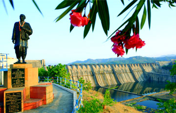
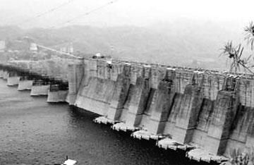
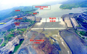
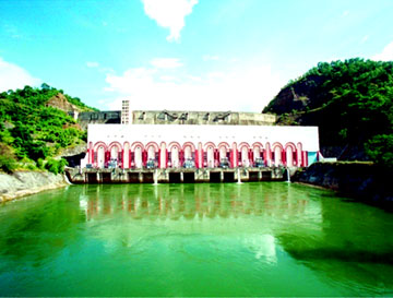
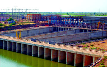
The total length of the dam is 1.2 km, consisting of 64 monolithic blocks conforming with the gorge width available at the site. The spillway length provided is 690 m, comprising 30 monolithic blocks, and 510 m of non-overflow (NOF) segment comprising 34 monolithic blocks. On the right flank there are 12 monoliths, of which six are of Power dam and six of the NOF segment. On the left flank there are 22 monoliths of NOF blocks, followed by 30 blocks of spillway seven of the auxiliary and 23 of the main. The spillways together are capable of catering to the flood levels stipulated by DDRP and other experts, mentioned above.
The dam will be the third highest concrete dam (163 meters) in India, the first two being Bhakra (226 meters) in Himachal Pradesh and Lakhwar (192 meters) in Uttar Pradesh. In terms of the volume of concrete involved for gravity dams, this dam will be ranking as the second largest in the world with an aggregate volume of 6.82 million cu.m.
The first is Grand Coulee Dam in USA with a total volume of 8.0 million cu.m. This dam with its spillway discharging capacity of 85.00 cumecs (30.00 lac. will be the third in the world, Gazenba (1.13 lac cumecs in China and Tucurri (1.0 lac cumecs) in Brazil being the first two.
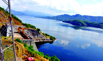
The Full Reservoir Level (FRL) of the Sardar Sarovar Dam is fixed at RL 138.68 meters (455 feet). The maximum water level is 140.21 meters (460 feet) while minimum drawdown level is 110.64 meters (363 feet). The normal tail water level is 25.91 meters (85 feet). The top of the dam is 146. 4 meter.
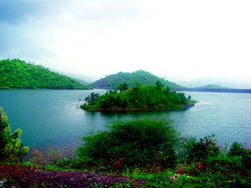
The gross storage capacity of the reservoir is 0.95 M ham. (7.7 MAF) while live storage capacity is 0.58 M ham (4.75 MAF). The dead storage capacity below minimum drawdown level is 0.37 M. ham (2.97 MAF) The reservoir could occupy an area of 37,000 ha. and would have a linear stretch of 214 kilometer of water and an average width of 1.77 kilometer.
During detailed discussions, N.G.K. Murthy, Expert Member and Consultant, Specifically advised that the size of the spillway selected be such that under no circumstances would a man-made flood be caused. He explained that in the initial stages of most major projects the designers and the hydrologists are all intimately connected with design and hydrology as they are actively involved in formulating the project. Later, when they become old, experienced hands, they either get transferred or they retire. Those who are to take charge later may not necessarily have the same kind of intimate knowledge or insight of the particular site. Man-made floods have often been caused due to wrong operation and opening of the service-spillway gates not commensurate with actual site situations. To avoid such an eventuality it was essential to provide an optimum number of gates and a very clear gate operation manual giving the complete Rule Curve. His advice was followed to the letter.
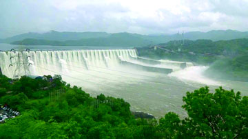
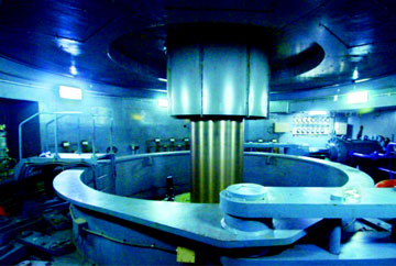
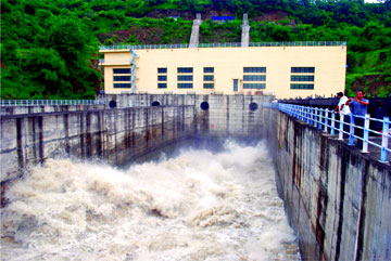
G River Bed Power House and Canal Head Power House
Both the SSP power houses- Canal Head Power House (CHPH-250 MW of Kaplan Turbine) and the River Bed Underground Power House (RBPH – 1200 MW of Reversible Francis Turbine) have been completed in all the respects and are regularly generating power. Due to the dam height having not reached the designed height, up EL. 146.60, generation is not at full designed potential.
Up to the end of Stage-II of the project , as contemplated in the NWDT Award, MP and Maharashtra would be in the process of developing their irrigation potential. After completion of Stage-IIi, and all the water allocated to both MP and Maharashtra would be fully utilised and as such there would be no surplus water flowing downstream of Narmada Sagar except regulated releases from the hydro-power projects in Madhya Pradesh. To overcome this eventuality, it has been contemplated that the remaining component of the Power House complex, the Garudeshwar Weir with crest elevation at EL 31.75 m, will have to be provided 11 km downstream of the main dam. Since, the turbines installed in the Underground River Bed Power House are Reversible, the weir will facilitate forming a tail pond pool to operate the turbines in pumping mode. Water from the pool will be pumped and restored in Sardar Sarovar reservoir behind the main dam, enabling power production in the RBPH. After Stage-III, and completion of the weir, the power produced by the RBPH would normally be used to fulfil the peak demands-normally three to four hours in the morning and in the evening. During non-peak hours the turbines would operate in pumping mode.
The power production of both the power houses of the SSP until now is of the order of 32000 MU. The revenue generated until now comes to Rs 65000 crores, whereas, the capital cost of the Dam and both Powerhouses is 6000 crores, that is, the cost has been already recovered.
H River Diversion
 |
The monsoon in this part of India lasts four months- June to September. The post-monsoon period of eight months. October to May is available for construction. The river diversion scheme envisages diversion of the post-monsoon flow through an open cut channel excavated in the river bed to the left of the deep river channel that normally carries post-monsoon flow. Two submersible cofferdams, one upstream and the other downstream of the dam seat area, were built across the deep river channel and two submersible bridges across the diversion channel for use during post-monsoon season. Construction sluices planned in two stages at foot of two spillway blocks were built in the diversion channel portion for construction. In order to accelerate the construction of dam and complete by January 1998, revision of diversion scheme was resorted to. It emerged that the second stage construction sluices required to facilitate construction of sloping aprons in and alongside the diversion channel which consisted of eight construction sluices in spillway blocks 44-45 with sill level at RL 35 m where not required and it was decided to have permanent sluices at RL 53m in blocks 44, 46, 48 and 50 to divert post monsoon flows.
I Seismicity and Safety of Dam
The Sardar Sarovar Dam (SSD) and reservoir are located in a crucial area in the Deccan trap province. The deeper and major earthquakes occur where tectonic plates are pushed together, as in the subduction zone along the Himalayas. The Deccan traps lie well within the Indian plateau, at a considerable distance from the plate boundaries. There are no global stresses being built up here. Thus the probability of major earthquakes (beyond Richter Magnitude 7.0) in this zone is very low.
However, the closest feature of interest for Sardar Sarovar is the Narmada-Tapi-Sone lineament, which some investigators consider seismogenic. Describing the seismo-tectonic environs of the Narmada extending from the Gulf of Khambhat in the west to the Sone Valley in the east, one view is that the river flows along a major fault zone and that the Narmada Valley is an elongated E-W to ENE-WSW trending subsidence zone forming a major rift. But other investigators like Jai Krishna et al. (Krishna, 1989) point out that there is no geological evidence that such a fault exists.
Earthquake data for peninsular India show that the highest magnitude of an Maximum Credible Earthquake ( MCE} can be 6.5. the fault and tectonic lineaments of relevance for SSD are as follows:
(i) Rajpandi and associated faults forming the eastern boundary of Cambay basin West Coast seismo- tectonic province.
(ii) Barkhadi- Barwani fault Shortest distance to the lineament from dam site is 55 km towards west. Shortest distance from site is 110 km east.
(iii) Piplod fault Shortest distance 12 km south of dam site.
(iv) Tilakwada-Bardoli fault Shortest distance 17 km north of dam site.
While it is plausible to associate a Richter magnitude 6.5 earthquake only with cases (i) and (ii) above, which are the only seismogenic lineaments that are capable/active, a ‘worst case scenario’ of a Richter magnitude 6.5 earthquake has been postulated at an epicentral distance of 12 km with a depth of focus of 18 km for case (iii), for conservative design estimates of ground motion characteristics.
For the preliminary design stage, an a-seismic design was evolved using a seismic coefficient of 0.125g as approved by NCSDP.
The detailed design of the dam section for SSD is based on the EPGA of 0.25g though a lower value of 0.21g was originally obtained through empirical procedure. The value of 0.25g for EPGA was considered in depth by the Dam Safety Review Panel. The project had consulted R.W. Clough of University of California, Berkeley, who in turn consulted Bruce A. Bolt of the same university and endorsed the adoption of EPGA of 0.25g.
J Siltation
As the issue of sedimentation was persistently raised by environmentalists and activists, the Narmada Planning Group (NPG) of the Government of Gujarat critically examined the problem in order to determine the feasible service life of the reservoir. With modifications based on the new rate of sediment worked out from the long-term inflow data of 1891-2009, Table 1 below gives the Feasible Service Time of SSP as estimated using the following three different methods and for different construction schedules of SSP and ISP:
- Empirical Area Reduction Method
- Area Increment Method
- Trigonometric Method
Considering the actual developments to date, Case nos. II and III are now irrelevant.
Table 1: Feasible Service Time of SSP (in Years)
|
SI. No.
|
Particulars
|
Feasible Service Time of SSP
|
|
Empirical Area Reduction Method
|
Area Increment Method
|
Trigonometric Method
|
|
Case I
|
Completion of SSP and ISP(Indira Sagar Project) together
|
499
|
705
|
722
|
|
Case II
|
ISP completed 5 years after SSP
|
473
|
679
|
696
|
|
Case III
|
ISP Completed 10 years after SSP
|
446
|
653
|
670
|
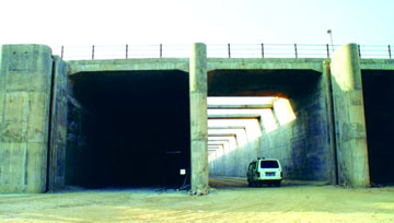
K Irrigation Bypass Tunnel (IBPT)
 |
Irrigation bypass tunnel is a normal and a common feature in multipurpose irrigation projects. Its main objective is to ensure continuous flows in the main canals if water flow through the canal-head power house is interrupted. This situation often arises when the power house is under repair, under a forced shut-down, in a situation beyond normal control, or for any other unforeseen reason. In addition to the above, the NWDT award, final orders, provide that whenever there is surplus water in a particular year, the party state can utilise the surplus as available on pro rata basis (shares of the party states). The Narmada Main canal has been designed to carry 1133 cumecs. Accordingly, in the year when surplus water is available over and above the peak requirement for irrigation, which will be passed through the CHPH, balance pro rata share of the surplus water can be passed through the IBPT. The IBPT for SSP was completed in the year 2001-02, so as to provide water to the Main Canal.
L Instrumentation
Instrumentation for the Sardar Sarovar Project was designed in consultation with experts of the DDRP comprising eminent engineers from India and abroad. For detailed layout of the instrumentation in the dam,Indian Meteorological Department (IMD), CWPRS and other expert bodies were also consulted. The latest instruments, worth about Rs.30 million, were acquired for the main dam and the seismic stations around the reservoir periphery.
The objectives of the instruments are twofold: Those embedded in or installed at the surface of dams and other hydraulic structures constantly monitor their performance in service and indicate the distress spots which call for remedial measures. Most hydraulic structures are built on conservative assumptions to provide for the unknowns in the design. Observations from the instrumentations will help to reduce these unknowns and place the future designs on a sounder footing.
Besides the normal instrumentation for recording temperature changes, seepage, uplift, stress, strains and deflection, there are seismic instruments installed to fulfill the critical need to monitor seismic activity and its impact within the body of the dam and in the reservoir vicinity. For SSP this scheme consists of nine seismological stations. Four each of these are on either side of the reservoir in MP and Maharashtra, and one is at Kevadia. These are meant to investigate the sources of seismic activity in the vicinity of Sardar Sarovar dam and also to evaluate any seismic activity that may be associated with the filling of the reservoir. These data are meant for use by earthquake engineers in the earthquake-resistant design of structures to be built in this region, and also may give important information to seismologists with regard to local earthquake mechanisms. In fact the last earthquakes which were felt near Bhavnagar in the Gulf of Khambhat in March 1989 on the 16th and at Chuda near Limbdi, south-west of Surendranagar on the 20th, were both recorded at the Kevadia observatory as 2.0 and 4.0 respectively on the Richter scale.
For proper recording and data, an online recording system with modern computers is installed both at the dam site and at Vadodara, to have on hand and to analyse the complete output data and results.
The information obtained through measurements promotes understanding of the influence of various parameters on structural behavior. Surveillance of the behavior of the structure and its foundations during operation is essential to guarantee the safety of any large dam. With the sophisticated instruments and computers installed on the Sardar Sarovar Dam and the ample precautions taken, there will be no difficulty in monitoring this large project, and in guaranteeing the safety of the dam.
4 Rehabilitation and Resettlement
There are 29 Major, 135 Medium and 3000 small Projects of Narmada Valley which are in different stages of either completion or nearing completion or at planning stage. The Resettlement and Rehabilitation (R&R) of all these ongoing Intra-State Projects is being governed by the provisions of R&R Policy of the State formulated for Narmada Projects except for Sardar Sarovar Project in which the whole gamut of R&R is being governed by the provisions of Narmada Water Disputes Tribunal (NWDT) Award and R&R Policy of the State Government being an Inter-State Project.
Applicability of Different Provisions of R&R Policy of the State for Oustee of Narmada Project INPRR - 2003 / NWDT Award
|
SI.
No.
|
Name of the Project
|
Applicability of the provisions of the policy/ NWDT Award
|
Remarks
|
|
1.
|
Indira Sagar, Omkareshwar, Man, Jobat, Upper Beda
|
Rehabilitation Policy for the Oustees of Narmada Projects as formulated by Government of Madhya Pradesh
|
This policy is being implemented to all ongoing projects of Narmada Valley.
|
|
2.
|
Sardar Sarovar Project
|
Provisions of NWDT Award and Policy of the State. All directives of Hon'ble Supreme Court regarding SSP
|
Directives of Hon'ble Supreme Court in WP(C) 319/94 & 328/2002 being implemented.
|
|
3.
|
Upper Narmada, Halon, Lower Go, Hoshangabad, Handia and Boras Projects.
|
National Policy on R&R for Project Affected Families - 2003 (NPRR- 2003)
|
To be implemented for all up coming projects of Narmada Valley.
|
There are different provisions of (R & R ) policies applicable to different ongoing Narmada Basin Projects. However only the provision applicable to Sardar Sarovar Project is illustrated in the table below.
|
Table: Provisions of the Policies Applicable in Sardar Sarovar Project
|
| |
|
|
Provisions of the Policy
|
As per NWDT award & State Policy for Narmada Projects
|
|
Compensation of Agriculture land
|
Agricultural land will be compensated as per sec. 23 of Land Acquisation Act (market value of the of the land compensation wells, pipelines and trees as per valuation report given by PHE, forest and Horticulture Departments + 30% solatium +12% interest (interest payable from date of notification of section 4)
|
| |
|
|
Compensation of Houses and Properties
|
Compenstion of houses and other immovable properties will be paid as per section 23 of Land Acquisation Act (as per CSR) + 30% solatium +12% interest (interest payable from date of notification of section 4)
|
| |
|
|
Rehabililitation Grant
|
1) Agricultural landless labourers families, SC/ST/small and marginal farmers families = Rs. 18,700/-
|
| |
2) Other families Rs. 9,350/-
|
| |
|
|
Employment Resources Grant for Productive Assets to Landless Persons
|
1) Rs. 49,300/- to landless agricultural labourers, landless SC & ST families.
|
| |
2) Rs. 33,150/- to other landless families
|
| |
|
|
Other Provisions Land for Land
|
Eligible families losing 20% or more agricultural land will be alloted land for land (minimum 2 hs. And maximum 8 ha.) The major sons of such families will also be alloted minimum 2 ha. of land or amount of SRP for purchasing of land.
|
| |
|
|
Transportation Grant
|
Free transportation or Rs. 5,000/- for transportation of their house hold goods to new R & R site.
|
| |
|
|
Residential Plots
|
90 x 60 = 5400 Sq.ft plot or Rs. 50000/- to each family in rural area.
|
| |
For Urban R & R site of Dharampuri the plot size of 40 x 60 = 2400 sq. ft or Rs. 50,000/-
|
| |
Joint families refusing the residential plot will have to take at least 1 plot minimum
|
|
Stamp / Registration fee
|
For purchase of Agricultural land or immovable property within M.P. up to the limits of amount paid to PAFs excluding transportation grant)
|
| |
|
|
Special Provisions
|
1) Option of acquiring total agriculture land if 75% of land holdings are acquired.
|
| |
2) Compensation of encroached land if encroachment is prior to 13th April 1987.
|
| |
3) Major sons and major unmarried daughters will be treated as separate family if they were major on the date of section 4 notification.
|
The latest figures regarding rehabilitation, available from the Sardar Sarovar Punarvasvat agency (SSPA) which was separately carved out for rehabilitation and Narmada Control Authority (NCA) is presented below.
State-wise Distribution of Affected Villages (AS of 31.07.2009)
|
State
|
Villages Affected
|
PAFs likely to be resettled
|
PAFs likely to be resettled in Gujarat
|
PAFs already resettled in Gujarat
|
|
Full
|
Partial
|
Total
|
|
GUJ
|
3
|
016
|
019
|
04744
|
04744
|
04744
|
|
MH
|
0
|
033
|
033
|
04204
|
00771
|
00771
|
|
MP*
|
1
|
191
|
192
|
37773
|
05579
|
05579
|
|
Total
|
4
|
240
|
244
|
46721
|
11094
|
11094
|
* In addition about 20,000 PAFs have been resettled in MP when the height of dam had reached 121 metres. Those remaining to be resettled number 12 to 15 thousand, all in MP.
PAF - Projected Affected Families
Environmental Aspects
Ministry of Environment and Forests, Government of India (MoEF-GoI), armed with the powerful Forest Conservation Act, 1980, subjected the Sardar Sarovar Project (SSP) to exacting environmental conditions before accepting it. Thus it became the first River Valley Project in India that is complying with stringent environmental standards.
The Narmada Water Dispute Tribunal (NWDT) constituted under Inter State Water Disputes Act gave its award for building the Sardar Sarovar Dam in December 1979. The project was one of the first in India to incorporate environmental impact assessment in the planning stage itself, even before the guidelines for such study were prepared by MoEF-GoI. A benchmark study, ‘Preliminary impact assessment of Sardar Sarovar’ by M.S. University of Baroda was Carried out in 1983. This was followed by a number of studies relating to all aspects of environment such as health, downstream impacts on fisheries, problems related to water logging, salinity, seismicity impact on flora and fauna and also the socio-economic analysis of the Project Affected Persons. Besides these specific studies there was a plethora of command area studies carried out on various aspects. For example, the Narmada Planning Group, once headed by the noted economist Y.K. Alagh, has carried out a total of 41 of studies grouped under Technical Studies (18), Socio-economic Studies (10), Agricultural Studies (6) and, Environmental Studies (7). There were also number of studies carried out by the Government, non-government and independent bodies making it one of the most exhaustively researched projects in India.
MoEF-GoI tested its guidelines foe environment impact assessment by subjecting SSP to one of the most exacting sets of conditions. After satisfying itself about the sustainability of Sardar Sarovar Dam, it granted clearance in 1987 under the Forest Conservation Act (FCA), 1980, with a condition that all amelioration activities would be carried out pari passu with the construction of the project. The Planning Commission reiterated these conditions while accepting the project.
One of the most glaring impacts of a river valley project is the loss of forest land that comes under the vicinity of the large man made reservoir. Tables 1 and 2 give an indication of the forest land diverted for SSP and the efforts of various states to carry out compensatory afforestation to mitigate that impact as per the provisions of FCA, 1980. In Gujarat it was estimated that approximately 828,000 trees would be submerged. Gujarat, therefore, has already planted more than 60 million saplings, i.e. approximately 77 plants for every tree clear felled. The species planted show a wide diversity suitable to the agro-climatic conditions of the region. The plantation programme in Gujarat included canal bank plantations which have a vast potential of an estimated 5300 hectares.
Table 1: State-wise Statistics of Specialised Land Use
|
State
|
Area of forest
diverted for SSP (ha)
|
Area of non-forest
land to be afforested (ha)
|
Achievement
(ha)
|
% task
|
|
Government of Gujarat
|
4523
|
4650
|
4650
|
100
|
|
Government of Maharashtra
(i) Owing to submergence
|
6488
|
6488
|
6326
|
97.5
|
|
Owing to R & R
|
4200
|
4200
|
3583
|
85.32
|
|
Government of Madhya Pradesh
|
2732
|
2190
|
X
|
X
|
|
Total
|
17943
|
17528
|
X
|
X
|
X - Not Reported
Table: 2 State - wise Statistics of Degraded Forest to be afforested.
| State |
Area of Degrade forest
To be afforested (ha.) |
Achievement
(ha.) |
% of task |
| Government of Gujarat |
9300 |
9300 |
100 |
| Government of Maharashtra |
12980 |
12977 |
100 |
| Government of Madhya Pradesh |
6550 |
X |
X |
| Total |
28830 |
X |
X |
Wildlife Affected Areas (Sanctuaries and National Park): The wildlife of the affected areas forms an important component of the Environmental Impact Area Study.
An expert group was also constituted to undertake detailed studies on improving the habitat of the sanctuaries in Narmada Command Zone, i.e. Shoolpaneshwar Sanctuary near Rajpipla, Blackbuck-Velavadar National Park, Nalsarovar Bird Sanctuary near Ahmadabad, and Wild Ass Sanctuary in the Little Rann of Kachchh.
It is expected that no serious adverse impact is likely to fishing and fishermen, but there will be some changes in the variety of fish and the method of fishing, which may reflect on the livelihood of fishermen. Detailed action plans have been prepared to develop the dam reservoir as a fishing gene pool. Every year fingerlings are released into the reservoir by GoG through the Environment Cell of SSNNL to Stock the reservoir with edible variety of fish. Adequate measures were taken to train habitats for sustainable fishing to fish in the periphery of the dam reservoir and mangrove plantations were taken up in estuaries to promote fishing.
Health: When a mega project comes into existence, various factors like creation of a man-made reservoir, long canal system and influx of human population around the project site can lead to health problems. The EIA identified the baseline indicators for vector transmitted diseases, including malaria, filariasis and schistosomiasis, and recommends alternative solutions for implementation. Initially, a study was taken up for schistosomiasis in the project area and it was inferred that it did not exist. A number of studies have been carried out on the health profile of the villages in the affected areas. A separate unit of preventive health organisation at Kevadiya was also set up. Intensive monitoring for malaria was regularly done in the project area.
Archaeology: A survey was carried out in Gujarat in respect of archaeological monuments affected due to submergence. Two ancient temples on the Narmada river banks in Shoolpaneshwar and Hampheshwar have been shifted to newer sites above the submergence area. In MP, seven temples have been relocated.
Seismicity: Studies on reservoir induced seismicity (RIS) and rim stability were carried out by Geological Survey of India, Central Water and Power Research Station, Roorkee and world Bank consultants. Based on the recommendations emanating from these studies, various modifications in the dam design were carried out.
There were other aspects of the Environment Impact Assessment of the River Valley Project, like Ground Water Modelling, dealing with rise of ground water over time as the canal water starts following in; understanding the drainage pattern; distribution of water etc. which have been addressed systematically by SSP. Rehabilitation-a prime environmental concern has also been addressed with sensitivity and empathy.
It is to be stressed that the re-establishment of green cover that would otherwise have been lost in such a massive river valley project will benefit millions of people for generations. The environmental mitigation measures carried out by SSP are unparalleled anywhere in the country.
6. Planning Of Canal System
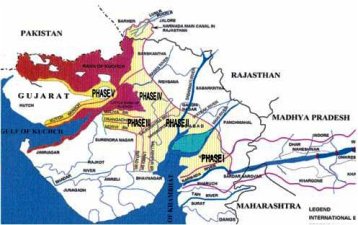
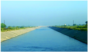
The Narmada Main Canal (NMC), with a length of 458 km in Gujarat, further extending 74 km into Rajasthan, is the world’s largest concrete lined canal with a discharge carrying capacity of 1133 cumecs at its head. Designed to annually convey 11.7 BCM of water to quench the thirst of Gujarat and Rajasthan, it has been completed and water has been flowing all the way through since March 2008. It is proposed to use this canal not only for conveyance but also for storage of water to improve the response time of the system. At full supply depth, it can store 220 MCM – a volume that can serve domestic needs of a mega-city like Ahmedabad for the entire year. This storage, available round the clock, is more than the capacity of dams like Watrak and Bhadar in Gujarat.
This unique contour canal has a command area of 1,845,000 hectares on its left bank. Along its length of 458 km up to the Gujarat Rajasthan border, 634 structures have been built, of which 114 are control structures (head regulators, cross-regulators and escapes), 231 are cross-drainage works for crossing natural streams and other canals ( aqueducts, siphon aqueducts, canal siphons, drainage siphons and super-passage) and 289 are communication structures ( road and railway bridges).
7. Strategy for Expeditious Completion of Canal System
 |
SSP has successfully adopted path-breaking approaches for arriving at technological solutions at every step of its implementation engineering issues dealt with in the different project components like dam, hydropower, canal, canal structures and so on, had no off-the-shelf solutions existing anywhere in the world. Some of the unique features built into the planning of the project are concrete-lined canals to reduce conveyance losses, use of control volume concept for design of distribution systems, efficient water use allocation with optimised crop planning for 13 different agro-climatic zones of the command, extensive irrigation to a 180,000 ha area with just 21 “delta supported by the use of 8” of groundwater, deepening of village tanks for borrowing soils for canal embankments, computerised automated operation of canal system, participatory irrigation management through Water Users Associations, and promoting micro-irrigation systems like drip and sprinkler for efficient water use. In order to complete the project and the command area within the time schedule, the following measures have been adopted leading to good governance.
The Road Map
An ambitious and yet achievable road map has been prepared with an overall target of completing the Project by 2014-15. This includes the remaining work of the Main Dam and works of Branch Canals, Distributor Canals, Minors, Sub-minors and the structures thereon. This in turn calls for a massive construction programme in the next three years(starting from 2010), for which adequate financial resources, contractual framework, land acquisition, designs, project monitoring, quality assurance and control have been planned in advance. A policy decision has been taken to implement the canal network in such a way that it leads to successive development of the command area and not as scattered works in different canal segments. Wherever possible, the works of delivery distribution network are also being initiated concurrently to ensure that water reaches the farms through the planned canal network.
Command Area Development
Importance of command area development activities cannot be overemphasised because of their role in realising real irrigation benefits. The SSP command area fully developed to Sub-minors level is around 348,000 ha. Over 1.5 million ha command area is yet to be developed to this level, which is challenging by any standards despite the fact that another 155,000 ha area has been developed to Minors level. Year-wise and area-wise detailed planning has been done to complete the remaining Command Area Development (CAD) works and their progress is being monitored. Experience has shown that due to missing links the downstream command remains deprived of water. Such missing links may be due to non-availability of land, road, railway or other utility crossings, crossing of any existing canal of other medium/minor project etc. Efforts are therefore on to identify and remove such missing links and ‘actual water flow’ is made the target rather than misleading percentage progress in terms of physical quantities. A comprehensive implementation plan encompassing various CAD activities is being prepared for each area. CAD activities generally considered include construction of water courses (Sub-minors) and field channels; land levelling and land shaping; provision of field drains; assisting the farmer in development of ground water resources and conjunctive use of surface and ground waters; provision of a network of basic infrastructure roads and farm roads; developing, marketing and warehousing facilities; establishing agricultural research-cHOT-demonstration farms; strengthening of cooperative structure for input and credit facilities to farmers; arrangements for timely supply of inputs like seeds, fertilisers, pesticides and consolidation of landholdings where necessary.
Expediting Land Acquisition
The land acquisition for canals is to be carried out under the Land Acquisition Act. The land required so far was in the South and Central Gujarat, where prices are higher than those in the command areas of North Gujarat, Saurashtra and Kachchh. Most of the land acquisition now required is in the areas of North Gujarat (Banaskantha and Patan districts), Saurashtra and Kachchh region, which are part of the drought prone areas, and where land holdings are generally larger. With low to medium rainfall, high annual variation and semi-arid to arid climate enhancement of agricultural production in this region depends heavily on the availability of water. The farmers are volunteering to hand over land for construction of canals so that they can avail of irrigation benefits at the earliest. With the cost of groundwater irrigation becoming astronomical and agricultural land getting degraded owing to the use of high TDS groundwater for irrigation, these farmers are the victims of environmental degradation caused by excessive mining of groundwater, and Narmada water could address these problems to a large extent. Besides this, it has been decided to pay the land acquisition compensation at the Jantri Rate (official market rate) and acquire land through mutual consent, so that it may become available earlier and the farmers get fair compensation without resorting to court intervention. A High Level Committee headed by the Revenue Minister is steering and guiding the land acquisition process. The committee meets every week and several meetings are also held at different district and taiuka headquarters. This initiative has helped address the land acquisition related challenge adequately and in with participation of the beneficiaries. From the seven districts of North Gujarat and Saurashtra and from Kachchh district, around 10,000 ha of private land has been acquired which has facilitated execution of canal network construction in these regions.
Outsourcing of Joint Measurement and Preparation of LAQ Proposals
As per the land acquisition procedure, a joint measurement survey needs to be undertaken in six times the land area actually required to be acquired. With a view to expedite this, a conscious decision was taken to outsource this activity instead of carrying it out departmentally. This practice is being followed since over a year and it has proven to be very successful in expediting joint measurements of the land proposed to be acquired. Around 60 professionals are working on this aspect using the latest total station technology. As a result joint measurement survey in 221,950 ha area is complete and only 32,000 hectare area remains to be measured. This has helped in the preparation of Land Acquisition proposals and further processing.
Outsourcing of Survey and Design Works
For design of the Main Canal, Branch Canals and Sub-Branch Canals various types of control, communication and cross-drainage structures, a centralised in-house design approach has been adopted and more than 500 structures have been thus designed during last year. About 95 per cent of the designs are complete for all the Branch Canals except Kachchh Branch Canal for which the design work has been partly outsourced to RITES Limited. For the distribution network, a major constraint faced during implementation was the inability to provide designs to the contractors in time, resulting in delay in implementation. SSNNL, therefore, decided to outsource this task. For expeditious completion of Network Planning including designs of Distributaries, Minors and Sub-Minors, in-house efforts are being supplemented by consulting organisations like WAPCOS. For major works like pumping stations on the Saurashtra Branch Canal and Kachchh Branch Canal, organisations like NTPC and Tata Consulting Engineers have also been consulted.
Initiating New Works under Item Rate/EPC Contract System
For completion of the remaining works of Sub-branch canals of Saurashtra Branch, namely lining of the Morbi, Vallabhipur, Dhrangadhra and Limbdi Sub-branches, and distribution network in Maliya, Vallabhipur, Dhrangadhra, Limbdi, Botad and Morbi branch canals, 28 tenders worth around Rs. 15 billion have been invited, which are being finalised after evaluation. This will help in irrigating over 500,000 ha command area of the drought prone Saurashtra region.
For want of detailed geotechnical investigations, designs and network planning some of the works of Kachchh branch canal were originally planned to be taken up after two to three years. However, recognising that many experienced project engineers are due to retire, it was felt necessary to synchronise the works of the Kachchh region with those of Saurashtra. For bringing it forward and to further expedite the work progress in developing Command Area, the EPC (Engineering, Procurement and Construction), EPC mode of contracting is now resorted to, which will include survey, geotechnical investigations, design of canals and canal structures and network planning.
Such combination of Item Rate and EPC contracts, each with a time limit of 18 to 24 months, will help in early realisation of the potential benefits of SSP in the command areas in Patan, Banaskantha, Kachchh and Saurashtra regions.
Optimum Utilisation of Working Seasons
A detailed programme was worked out for inviting tenders for the remaining canal works within three months so that all the works can begin at the earliest and completed soon.
State-of-the-art tools for Construction Project Management are being used to prepare a meticulously prepared project-specific Work Plan taking into account all resources and constraints. Project Engineers are being trained in this subject to enable them to monitor the progress of each component.
Project Management Consultants
Each construction package of the canal network is a project by itself and has to be monitored and managed professionally. Project Monitoring Consultants are, therefore, being appointed to oversee execution so as to cope with technical manpower shortage and to effectively and efficiently monitor the Project for timely completion.
Third Party Quality Audit Consultant
Each contractor is primarily responsible and contractually obliged for quality assurance of work. Operation and maintenance for a further period of two to five years is also an integral part of the contract. However, to further ensure and monitor the quality of works on sustained basis, a third party quality consultant is being appointed to monitor and ensure the quality of the works in progress.
Participatory Irrigation Management
For equitable distribution and efficient utilisation of water in the command areas, water for irrigation is planned to be delivered through Water Users’ Association—a co-operative society of farmers— through the provisions of Participatory Irrigation Management (PIM) Act, 2007. The WUAs are also expected to operate and maintain the delivery system including the Minors and Sub-minors, and recover water charges from users. This would ensure better physical performance and financial working of the irrigation system. A total of 4,780 WUAs are to be formed in the command area in 14 districts, of which about 1,600 have already been registered. Efforts to sensitise and operationalise more WUAs are being made, using methods ranging from interactive group discussions to intensive training programmes.
Multidisciplinary Coordination Committee
A district level committee, headed by the Collector, has been constituted for up-scaling PIM activities. This Committee consists of elected members, representatives of WUAs, Deputy Conservator of Forest, District Agriculture Officer, Engineer-in-Charge of command area. It also includes NGOs, chosen to promote WUAs to elicit farmer participation in water distribution, and to facilitate efficient water use and adoption of best water use practices, encourage PIM, resolve local issues effectively and in a timely manner. This committee has also been delegated financial powers to deal with various issues. The initiative would also help sensitise and operationalise the WUAs effectively.
Separate Wing for O&M of Main Canal
NMC has been completed and the water has been flowing right up to Rajasthan since March 2008. The 458 km long main canal, which is 458 km long, is the artery created under SSP to transport water to different regions. To operate and maintain this canal comprising more than 600 structures, a separate wing has been created and made functional through three divisional offices equipped with necessary manpower and infrastructure.
Promoting Micro-Irrigation
Under the Command area, in order to popularise MIS. a pilot project each is being implemented in 73 talukas. This is proposed dovetail the State’s scheme with the Central Government Scheme under CADWM in order to facilitate larger fund flow. GoG has also taken pioneering initiatives to promote Pressurised Irrigation Network System (PINS) and MIS. The Project Authorities have undertaken the exercise of exploring the potential of implementing drip irrigation practices wherever possible, considering the existing cropping pattern and its suitability for drip technology. The State government has set up a Special Purpose Vehicle to implement it, called Gujarat Green Revolution Company (GGRC). The government is also providing a subsidy to the extent of 50 per cent for drip irrigation in the normal areas and 75 per cent in the tribal areas towards capital costs. Project Authorities and GGRC are taking all steps to popularise this scheme in the command area. The initiative of the government to introduce metering and pro-rata pricing of electricity for new agricultural power connections is encouraging farmers to adopt micro-irrigation systems.
Financial Resources
With the Planning Commission’s nod to the revised estimate of Rs. 392.4 billion for the project and the Environmental Sub-group of NCA’s consent to raise the dam height to 138.68 metres, the project is all set to embark upon the remaining works in the next three financial years and to create additional 1.3 MHa Irrigation Potential. Apart from enhanced state provisions in terms of Annual Development Plans, financial support under central schemes of Accelerated Irrigation Benefit Programme (AIBP) and Command Area Development Water Management (CADWM) is also being sought.
E-Tendering
All major bids are invited in e-rendering mode so as to ensure transparency and responsiveness in the process. Competitive bidding in two stages—Technical and Financial—is followed to arrive at the least-price workable contracts. Tenders worth about Rs. 50 billion have been invited during the financial year 2010-11. Of these, tenders for 51 works worth around Rs. 10.97 billion have been evaluated and finalised and for another 49 works worth around Rs 39.1 billion tender evaluation is in process.
Author
 |
K S Srinivas, a graduate in Civil Engineering from Lukhdhirji Engineering College, Morbi Gujarat State in 1977. He is also a Post Graduate from I.I.T (MUMBAI) in Structural Engineering In 1979 and began his career with Vakil, Mehta, Seth Structural Consultants. Subsequently, he joined Roads & Buildings Department Government of Gujarat. After his selection as Direct Recruit Executive Engineer in Irrigation Department through Gujarat Public Service Commission, he was appointed in Sardar Sarovar Project. Since then, till his retirement in January 2013, he served in the project in almost all facet of Civil Engineering, that is, Design, Construction, Quality Control, and Contracts Etc. He rose from Assistant Executive Engineer to Chief Engineer and also held charge as Director for three years. |
References
Sardar Sarovar Project on the river Narmada [vol 1,2,&3] By R.Parthasarathy, Ravindra H, Dholakia- published by CEPT University Press, Ahmadabad.
There are 38 branch canals off-taking from NMC to serve a vast command of 1.8 million hectares in 15 districts. The largest of these is Saurashtra Branch Canal which is 104.46 km long and discharges 424.80 cumecs. To negotiate the peculiar land topography, with falling ground from Ch. 0.0 to 59.0 km by about 52.0 m and thereafter, from 59.0 to 104.460 km, a rising ground by about 66.0 m before tailing into Bhogavo-II reservoir, three power stations at fall points and five pumping stations at lift points are planned. A total of 48 MW hydro-power is planned to be generated at the three fall structures at Ch. 5.15 km, 17.76 km and 32.94 m, each with a vertical drop of 10.9 m. Thereafter a total lift of 71 m is provided by a series of five pumping Stations at Ch. 66.518 km, 77.165 km, 87.95 km, 93.205 km and 102.84 km, with pumping head ranging from 10.8 m to 17.025 m. In these five pumping stations, which are the largest in India, there are 26 Concrete Volute Pumps, each of 20 cumecs capacity, and 22 Vertical Turbine Pumps of 5 cumecs capacity each. A single Concrete Volute Pump of 20 cumecs capacity could serve the daily water requirement of Burj Dubai in just 48 seconds.