Surveying Meets New-Age Technology
| A Civil Engineering project most often takes its form and shape on an Architect’s table and its sinews and muscles are added on by a Structural Engineer. Before it stands on its foundations serving the purpose for which it was conceived, the Architects plans have to be transformed to the ground. The science and art of performing this procedure is surveying and setting out. Surveying is the art of preparation of plans and maps from measurements made on or near the surface of the earth. The opposite process of |
 |
transferring the measurements of the building from the plans of an Architect to the ground is setting out.
Both procedures of surveying and setting out involve working in the open ground under inclement weather conditions and so, are not much liked by the surveyors who these days prefer to work inside comfortable ambience. Electronic measuring equipments have reduced much of the tedium but still a surveyor’s job is hard. Modern surveying involves sophisticated instruments, methods of analysis based on higher mathematics, computational systems and techniques making it a rigorous discipline of study. Historically, surveying has been on integral part of human civilization since man began to own a piece of land for his use. In ancient India, Egypt, Mesopotamia, Greece and Rome land measurement was prevalent for both civil and military purpose.
Basic methods and simple devices to measure distances and directions were used. Heron, the Elder of Alexandria, around 100 BC wrote a treatise on surveying of that age. He developed the Dioptra, which resembles a transit, to measure angles. He gave details about finding the area of a triangle using the lengths of its three sides. Romans used an instrument called the Groma to set right angles. From then on till the 14th century not much seems to have happened on the survey front. But thereafter many developments took place in the form of the magnetic compass, the plane table and the theodolite. Galileo’s invention of the telescope gave much impetus and the improvements in optics saw the advent of levels, theodolites, sextants, tachometers, etc., Use of light weight materials brought further advances in calibration and accuracy in measurements. Aerial photography and photogrammetric methods revolutionized surveying methods.
- Incidentally, the history of Survey of India makes a fascinating reading which includes the saga of making measurements of very long line in the plains of Bihar, by Radhanath Shikdar, who determined the elevation of the highest peak in the Himalayas which was later named as Mount Everest after the then Surveyor General, Sir George Everest.
Land Surveying Summit-2013
| The science of accurately finding out the terrestrial or the three dimensional position of points, distances and angles between boundaries and lands has witnessed tremendous advancements in the surveying technology. On the occasion of National Survey Day celebration, Association of Engineering and Surveying Consultants, Department of Civil Engineering B I T and GIS recently, organized a seminar—Land Surveying Summit-2013 in Bangalore. |
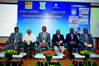 |
‘Built Expressions’ took part in the summit and interacted with domain experts. Excerpts-
| The knowledge exchange on surveying technological improvements such as LiDAR (LIght Detection and Ranging), Remote Sensing, e-surveying, Mapping and aerial Photogrammetry were given a thrust in the seminar. Mr. S. Hemanth Reddy, chief executive officer, Sir M V Institute of Engineering Skills and organizing secretary of the event says, |
 |
“Even though an enormous progress has taken place HhrmHHjfjfin the surveying space, awareness on the technology and products is still low. Hence, we felt the need of disseminating recent surveying techniques to the engineering fraternity.”
Mr. K B Appachu, retired official, Survey of India, enlightened the participants on how surveying in India has evolved over the years. Other dignitaries presented during the seminar were Mr. Venkatesh R Sheshappanavar, Col. M L Shanbhag, Mr. G Namasivayam and G S Kumar among others.
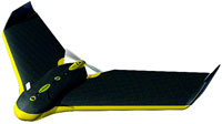
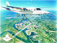
Aerial Photogrammetry
|
Advanced technology in surveying can come handy in preserving land records. Brig. J S Ahuja (retd), past director Survey of India pointed out while giving a presentation on 'Modernization of land records, using the technology of Aerial Photogrammetry--A step towards good governance' that land and corruption have a direct relationship. Countries having a proper land records found to be least corrupt. Hence, updated land records guarantee the ownership rights through law.
He said non-availability of old records is a major concern to both individuals and the government. Currently, for mapping land parcels, the available technologies are ground method, aerial photogrammetry and high-resolution satellite imagery. Brig. Ahuja said, "Surveying through aerial photogrammetry allows obtaining a fair data. Through this technology, land parcels are captured in the form of photographic images in digital mode hence, there will be accuracies of dimensions of land parcels as laid down in Land |
|
Survey Act. By using this technology, availability of permanent, durable and tamper proof record for future use can be achieved."
To bring in land record transparency, government has few tasks to be addressed such as updating of descriptive cadastres, digitization of a land Parcel Maps and survey of division made in fragmented land parcels. Further, sale of lands, division of land parcels, acquisition by government and natural calamities should be surveyed for better land record governance. In this view, aerial photogrammetry can be a well-oiled solution for land record transparency.
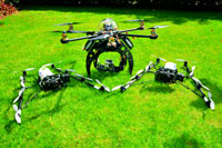
LiDAR
Among the latest surveying products, LiDAR has grabbed a significant attention in surveying methods. The application of LiDAR in civil engineering is enormous with its use in built survey, accident spot analysis and in the analysis & renovation of heritage structures. “With its active sensing system, it can be operated in night times. Three-dimensional images can be obtained under highly demanding environmental conditions,” says Mr. Nagaraja, director, MAPPA Consulting Engineers. Using LiDAR is close to having site on your desktop as it offers remote date acquisition, land-based photogrammetry, aids record preservation and thus avoids re-visits to the site.
Remote Sensing
Remote Sensing is the science of art obtaining information about an object, area or phenomenon through the analysis of data acquired by a device that is not being in contact with the object, area or phenomenon under investigation. Dr. M.S Ganesh Prasad, professor at National Institute of Engineering while giving a presentation on ‘Fundamentals of Remote Sensing,’ said, “It gives a holistic data approach to surveying as Remote Sensing gives a visual image interpretation such as tone, texture, size, shape, shadow and pattern of an object, area or phenomenon. For instances, identification and demarcation of target areas for mineral occurrence, underground coal fire detection and urban planning Remote Sensing plays a crucial role.”
However, three categories of Remote Sensing are available—Vehicle/ground-based sensors, aircraft sensors and satellite sensors. LANDSAT (USA), SPOT (France), IRS (India) and NOAA (USA) are a few well-known satellite sensors.
Several surveying solution providers demonstrated their products such as LiDAR and Laser Scanner during the seminar. Autodesk, a 3D design, engineering and entertainment software provider too has a surveying software tool-AutoCAD Civil 3D, from its Building Information Modeling solution. Mr. Rajagopal Nair, regional sales manager-AEC & ENI, Autodesk India Pvt. Ltd. said, "AutoCAD Civil 3D helps in surveying and mapping, soil excavation site planning and road design.
China's Changjiang Institute of Survey, Planning, Design and Research (CISPDR) an engineering, surveying, planning, design, and construction services on major public works projects in China and other parts of the world adopted Auto CAD Civil 3D product for one its largest water conservancy project ever undertaken--Three Gorges Dam project. Our product offered CISPDR a quick, efficient and accurate creation of 3D models and channel designs throughout the project."
Conclusion
It is important to realize that accuracy more than what is required for a particular job results in higher cost and greater time. Accuracy in measurements will have to be decided on the basis of the purpose of the survey and before the survey is taken up.
Precision refers to the care and refinement with which a measurement is made. It is dependent on the capability of the instruments employed and the competency of the surveyor. Accuracy refers to the nearness of the measured value to its true value.
If measurements in a project are to be consistent with the purpose of the project, the precision of angles should correspond to the precision of distances related. The error in the location of a point due to an error in angle should not be very much different from its error in location due to an error in the distance.